Bassam Saleh1* and Samih Al Rawashdeh2 1 Department. of Surveying and Geomatics Engineering., Faculty. of Engineering., Al-Balqa’ AppliedUniversity, Al-Salt 19117, Jordan.
2 Department. of Surveying and Geomatics Engineering., Faculty. of Engineering., Al-Balqa’ AppliedUniversity, Al-Salt 19117, Jordan.
Download Citation:
|
Download PDF
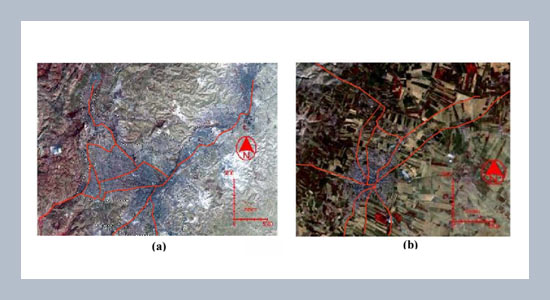
Urban environments are among the most dynamic systems on earth. Rapid urban expansionnecessitates proper planning to avoid profound negative environmental and socioeconomicimpacts. Geographic Information Systems (GIS) and Remote Sensing (RS) technologiesprovide very efficient tools to collect and analyze the information necessary to detect changes inurban areas that conventional surveying technology can't deliver in a timely and cost effectivemanner. GIS and RS techniques were used in this work to locate and estimate the expansion ofurban areas in three Jordanian cities: Amman, Ma'daba and Irbid. Rapid urbanization and industrializationhave caused not only social problems, but also environmental and socioeconomicproblems in most of the Jordanian cities. Aerial photographs and LandSat images were used toidentify urbanized areas and to quantify urban expansion in the above-mentioned cities for periodsdating from 1918 to 2002. The results show a massive urban expansion in these cities. Theurban area of Amman increased from 0.3 km2 in 1918 to 162.9 km2 in the year 2002. The city ofMa’daba expanded from 0.3 km2 to 11.2 km2 in the span of eighty-four years from 1918 to 2002.Meanwhile, the urban area of Irbid increased from 1.8 km2 to 38.2 km2 over a period of almostfifty years from 1953 to 2000. The entrance of war-time refugees and internal migration of Jordaniansover the years constitute the reason for this irregular but magnificent urban growth. Additionally,the study shows that urbanization in these three cities has found concentration nearmajor roads and fertile lands. ABSTRACT
Keywords:
Urban expansion, Remote Sensing, GIS, Urban Change Detection.
Share this article with your colleagues
[1] Leao, S., Bishop, I., and Evans, D. 2004.Simulating urban growth in a DevelopingNation's region using a cellularautomata-based model, ASCE- Journalof Urban Planning and Development,130, 3: 145-158.REFERENCES
[2] Stalker, P. 2001. “Handbook of theworld”, Oxford university Press, NewYork.U.S.A.
[3] Yang, X. 2002. Satellite monitoring ofurban spatial growth in the Atlanta metropolitanarea, Photogrammetric Engineeringand Remote Sensing, 68: 725-734.
[4] Cowen , D. J., and Jensen, J. R. 1998.Extraction and modeling of urban attributesusing remote sensing technology,people and pixels: Linking Remote Sensingand Social Science In: Liverman, D.,Moran, E. F., Rindfuss, R. R., and Stern,P. C., (Eds), National Academy Press,Washington, D. C.U.S.A.: 164-188.
[5] Mesev, V. 1998. Remote Sensing of urbansystems: Hierarchical integrationwith GIS, Computer, Environment andUrban Systems, 21, 3/4: 175-187.
[6] Longley, P. A. 2002. Geographical informationsystems: Will developments inurban remote sensing and GIS lead to'better' urban geography? Progress inHuman Geography, 26, 2: 231-239.
[7] Lo, C. P., and Yang, X. 2002. Drivers ofland use/land-cover changes and dynamicmodeling for the Atlanta, GeorgeMetropolitan Area, PhotogrammetricEngineering & Remote Sensing, 68, 10:1073-1082.
[8] Yang, X., and Lo, C. P. 2003. Modelingurban growth and landscape changes inthe Atlanta Metropolitan Area, InternationalJournal of Geographical InformationScience, 17, 5: 463-488.
[9] Rajeshwari, S. 2006. Management of theurban environment using Remote Sensingand Geographical Information Systems,Journal of Human Ecology, 20, 4:269-277.
[10]Chin, N. 2002. Unearthing the roots ofurban sprawl: A critical analysis of form,function and methodology, Center forAdvanced Spatial Analysis, Univ. Collegeof London, London. :47.
[11]Bourne, L. S. 1980. Alternative perspectiveson urban decline and populationdeconcentration, Urban Geography, 1,39-52.
[12]Giuliano, G. 1989. Research policy andreview 27: New directions for understandingtransportation and land use, Environmentand Planning A, 21, 2: 145-159.
[13]Sanchez, T. W. 2004. Land use andgrowth impacts from highway capacityincreases, ASC-Journal of Urban Planningand Development, 130, 2: 75-82.
[14]Chandra, A., and Thompson, E. 2000.Does public infrastructure affect economicactivity? Evidence from the ruralinterstate highway system, Regional Scienceand Urban Economics, 30: 457-490.
ARTICLE INFORMATION
Available Online:
2007-07-05
Saleh, B., Rawashdeh,. S.-A. 2007. Study of urban expansion in jordanian cities using GIS and remoth sensing. International Journal of Applied Science and Engineering, 5, 41–52. https://doi.org/10.6703/IJASE.2007.5(1).41
Cite this article: