Samih Bashir Al Rawashdeh *

Survey and Geomatics Engineering Department, Engineering Faculty, Balqa Applied University, Al-SALT, Jordan


Download Citation: |
Download PDF


ABSTRACT


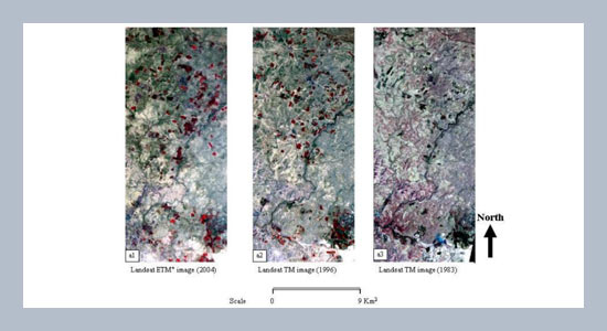
This paper describes the status of irrigated areas in dry zones in the eastern parts of Jordan. These areas suffer from the salinity problem due to over pumping from the underground water and this recommends measures to achieve long term sustainability using advanced tools like remote sensing (RS). Employing these techniques is a very important issue these days as they aid planners and decision makers to make effective and correct decision and designs. They allow continuously monitoring any change and any intended plans to secure their success or rectification to meet the requirements. The endless abilities of RS allows doing the most tedious work in a flexible, fast and accurate manner, especially with the availability of more and more satellite images and the improvement of their quality with time. In this paper, we presnet a new methodology of change detection based on Normalized Difference Vegetation Index (NDVI) using three Landsat Thematic Mapper (TM) and Enhanced Thematic Mapper Plus (ETM+) satellite images for three different dates 1983, 1996 and 2004. These images are processed and analyzed using RS software. The results proved the efficiency of this method of change detection in detecting the deteriorated parcels due to the salinity caused by over pumping from ground water and the state of the land productivity over time.


Keywords: Remote sensing (RS); normalized difference vegetation index (NDVI); salinity; landuse and land cover; irrigated area; land productivity.


Share this article with your colleagues


REFERENCES


  1. [1] Rajitha, K., Mukherjee, C., and Vinu Chandran R. 2007. Applications of Remote Sensing and GIS for Sustainable Management of Shrimp Culture in India. Journal of Aquacultural Engineering, 36: 17.

  2. [2] Sanchez, W. 2004. Landuse and Growth Impacts from Highway Capacity Increases.  ASC-Journal of Urban Planning and Development, 130: 75-82.

  3. [3] Sunar, F. 1998. An Analysis of Changes in a Multi Dataset: A Case Study in the Ikitili Area. International Journal of Remote Sensing, 19: 225-235.

  4. [4] Clarke, D. 1993. Satellite Remote Sensing of Marine Pollution. International Journal of Remote Sensing, 14:  29885-30043.

  5. [5] Belaid, M. 2003. Urban Rural Landuse Change Detection and Analysis Using GIS and RS Techniques. Presented in the 2nd FIG Regional Conference, Marrakech, Morocco, 2003.

  6. [6] Rassoul, S. 1992. “Requirements for Terrestrial Biospheric Data for IGBP Core Projects International Geo Sphere- Biosphere Program- Data and information System Working Paper 2”. University of Paris VI, France.

  7. [7] Hafeez, M. and Khan, S. 2008. Remote Sensing Application for Estimation of Irrigation Water Consumption in Liuyuankou Irrigation System in China available on, http://www.mssanz.org.au/modsim05/papers/hafeez.pdf, 1375-1387, accessed in October 20/2010.

  8. [8] Peyman, A. 2010. Soil Salinity in Irrigated Area under Qazvin Plain Network Using Satellite Imagery. Presented in the 9th International Drainage Symposium held jointly with CIGR and CSBE/SCGAB Proceedings, Published by the journal of American Society of Agricultural and Biological Engineers IDS-CSBE-100164, June 13th to June 16th, 2010.

  9. [9] Rahman, M.  Hedayutul, I., and  Shareful, M. 2005.  Change Detection of Winter Crop Coverage and The Use of LANDSAT Data with GIS. The Journal of Geo-Environment, 4: 1-13.

  10. [10] Emrullah, D., Ziliani, F., and Gerek, O. 2010. Change Detection with Automatic Reference Frame Update and Key Frame Detector. Available on, http://www. google.jo/search?hl=ar&source=hp&q=CHANGE+DETECTION+WITH+AUTO MATIC+REFERENCE+FRAME+UPDA TE+AND+KEY&meta=&aq=f&aqi=&aql=&oq=&gs_rfai=, date of accessing: November02/2010.

  11. [11] Lo, L. and Yang, X. 2002. Drivers of Land Use/Land –Cover Changes and Dynamic Modeling for Atlanta, George Metropolitan Area. Journal of Photogrammetric Engineering and Remote Sensing, 68: 1073-1082.

  12. [12] Royal Jordanian Geographic Center. Topographic Maps at scale (1:50000).

  13. [13] Jordan Natural Authority. Geological Maps at Scale (1:50000).

  14. [14] Brivio, P. A., Giardino, C., and Zilioli, E. 2001. Determination of Chlorophyll Concentration Changes in Lake Garda Using an Image-Based Radiative Transfer Code for Landsat TM Images. International Journal of Remote Sensing, 22: 487-502.

  15. [15] Teillet, M. and Fedoesjeves, G. 1995. On the Dark Target Approach to Atmospheric Correction of Remotely Sensed Data. Canadian Journal of Remote Sensing, 21: 374-387.

  16. [16] Wang, Y., Woodcock, E., Buremann, W., Stenberg, P., Violopio, P., and Smolander, H. 2004.  Evaluation of the MODIS LAT Algorithm at a Coniferous Forest Site in Finland. Journal of Remote Sensing of Environment, 91: 114 -127.

  17. [17] Sellers, P. J. 1985. Canopy Reflectance, Photosynthesis, and Transpiration. International Journal of Remote Sensing, 6: 1335-1372.


ARTICLE INFORMATION


Received: 2011-04-02
Revised: 2011-09-12
Accepted: 2011-09-15
Available Online: 2012-06-01


Cite this article:

Rawashdeh, S.B., Al. 2012. Assessment of change detection method based on normalized vegetation index in environmental studies. International Journal of Applied Science and Engineering, 10, 89–97. https://doi.org/10.6703/IJASE.2012.10(2).89