Ping-Sien Lin1, Ji-Yuan Lin2*, Shang-Yuh Lin2, and Jiunnren Lai2 1 National Chung-Hsing University,National Chung-Hsing University,250 Kuo-Kuang Rd., Taichung, Taiwan, R.O.C.
2 Dept. of Construction Eng., Chaoyang University of Technology,Dept. of Construction Eng., Chaoyang University of Technology,168 Gifeng E. Rd., Wufeng, Taichung County, Taiwan, R.O.C.
Download Citation:
|
Download PDF
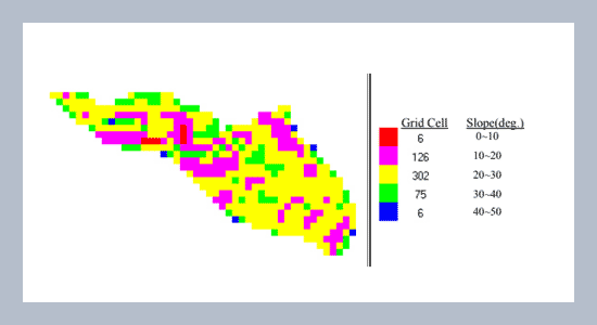
This paper aims to build an analytical process of assessing debris-flow hazards using multivariate analysis and geographic information system (GIS) techniques. The watershed of the Chen-Yu-Lan River is investigated in this study. Factors that are believed to be critical in the occurrence of debris flow are identified and considered in the assessment of debris-flow hazards. These factors used for assessing the debris-flow hazard are: (1) rock formation, (2) fault length, (3) naked-land area, (4) slope angle, (5) slope aspect, (6) stream slope, (7) watershed area, (8) form factor, and (9) cover and management factor. Using the spatial analysis feature of GIS, the indexes of these factors are calculated. By using principal component analysis (PCA) and discriminant analysis (DA) of all indexes according to each factor, the discriminant function of overall debris-flow hazard at any particular creek in the Chen-Yu-Lan River may be assessed. The applicability of the proposed approach for hazard assessment of debris-flow in the watershed of the Chen-Yu-Lan River has been confirmed with other researches and field observations in recent debris-flow events.ABSTRACT
Keywords:
debris-flow, hazard assessment, geographic information system, multivariate analysis
Share this article with your colleagues
[1] Council of Agriculture, Republic ofChina, 1996. The Map of Hazardous Debris-Flow Streams in Taiwan, Scale:1/250,000 (in Chinese).REFERENCES
[2] Shieh, C. L.and Jiang J. H. 1992. Studyon the judgment of dangerous valley ofdebris flow, Proceedings of Chinese 6th Conference on Hydraulic Engineering:262-273.
[3] Gupta, B. P. and Joshi, B. C. 1990.Landslide hazard zoning using the GIS approach - a case study from Ramganga Catchment, Himalayas, Engineering Geology,28: 119-131.
[4] Lin, M. L. and Jeng S. S. 1995. A preliminarystudy of risk assessment of debrisflow using GIS, Journal of the ChineseInstitute of Civil and Hydraulic Engineering, 7, 4: 475-486.
[5] Cheng, K. Y., Lin, L. K., and Chang, S. Y.1997. The filed investigation and GISapplication in a potential hazardous areaof debris flow, Debris-Flow Hazards Mitigation: Mechanics, Prediction, and Assessment, Proceedings of First International Conference, ASCE: 83-92.
[6] Lin, J. Y., Yang, M. D., and Lin, P. S.1998. An evaluation on the applicationsof remote sensing and GIS in the estimation system on potential debris flow,1998 Annual Conference of Chinese Geographic Information Society, (CDedition).
[7] Lin P. S., Lin J. Y., Hung J. C., and Yang M.D. 2000. Risk Assessment of Potential Debris Flows using GIS, Proceedings ofthe Second International Conference on Debris-Flow, Balkem: 431-440.
[8] Benda, L. and Cundy, T. 1990. Predictingde position of debris flows in mountain channels, Canadian Geotechnical Journal,27: 409-417.
[9] Auer, K. and Shakoor, A. 1993. A statisticalapproach to evaluate debris avalancheactivity in central Viginia, EngineeringGeology, 33: 305-321.
[10] Cheng, J. D., Wu, H. L., and Chen, L. J.1997. A comprehensive debris-flow hazards mitigation program in Taiwan, Debris-Flow Hazards Mitigation: Mechanics, Prediction, and Assessment, Proceedings of First International Conference,ASCE: 93-102.
[11] Nakagawa, H. and Takahashi, T. 1997.Estimation of a debris-flow hydrographand hazard area, Debris-Flow Hazards Mitigation: Mechanics, Prediction, and Assessment, Proceedings of First International Conference, ASCE: 64-73.
[12] Varnes, D. J. 1978. Slope MovementTypes and Processes. In: Schuster R. L.and Krizek R. J. (Eds), Landslide, Analysis, and Control. National Academy Science Transportation Research Board Spec. Report, 176: 11-33.
[13] Baily, R. G. 1971. “Land slide hazard srelated to land use planning in Teton National Forest, northwest Wyoming.Ogden, Utah: USDA Forest Service Intermountain Region”, 131 pp.
[14] Burroughs, E. R., Chalfant, G., andTownsed, M. A. 1976. “Slope stability inroad construction. Porland, Oregon:Bureau of Land Management”, Oregon State Office, 102 pp.
[15] Liaw, W. M., Chou H. T., and Lin M. L.1999. A case study of debris flow inducedby landslide, Journal of ChineseSoil & Water Conservation 30, 2:157-165.
[16] Zhou, B. F., Lee, D. J., Luo, D. F., Lu, R.R., and Yang, C. S. 1991. “A Guide for Debris-flows Hazard Mitigation”, Science Publisher Co. Ltd., Beijing: 4-5 (inChinese).
[17] Lin, P. S., Feng, T. Y., and Lee, C. M.1993. A study on the initiation characteristicsof debris flow in gravelly deposits,Journal of Chinese Soil and Water Conservation,24, 1: 55-64.
[18] Wang, R. Y. and Yea R. 1979. “Hydrology”,National Edition Center, Taiwan133 pp.
[19] Wohl, E. E. and Pearthree P. P. 1991. Debris flows as geomorphic agents in the Huachuca Mountains of Southeastern Arizona, Journal of Geomorphology, 4:273-292.
[20] Council of Agriculture, Republic of China, 1992. “Handbook of Soil and Water Conservation, Taiwan”: 1-156 -1-170 (in Chinese).
[21] Star J. and Estes J. 1990. “Geographic Information Systems- an Introduction”, Prentice Hall.
[22] Lin, C. Y. and Lin, W. T. 1999. An automaticde lineation of slope length factorfor watershed soil loss estimation, Journalof Chinese Soil and Water Conservation,30, 4: 313-320.
[23] Campbell J. B. 1987. “Introduction to REMOTE SENSING”, The Guilford Press, New York, 384-387.
[24] Kaiser, H. F. 1960. The Application ofelectronic computers to factor analysis, Educational and Psychological Measurement, 20: 141-151.
ARTICLE INFORMATION
Accepted:
2006-09-19
Available Online:
2006-09-25
Lin, P.-S., Lin, J.-Y., Lin, S.-Y., Lai, J., 2006. Hazard assessment of debris flows by statistical analysisand GIS in central Taiwan. International Journal of Applied Science and Engineering, 4, 165–187. https://doi.org/10.6703/IJASE.2006.4(2).165
Cite this article: