Samih Al Rawashdeh*, Balquies Sadoun, Omar Bayari, and Akif Al Fukara Balqa Applied University (BAU) Jordan, Faculty of Engineering, Department of Survey and Geomatics techniques
Download Citation:
|
Download PDF
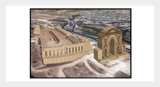
The archaeological heritage constitutes the basic record of the past human activities; the documentation and management of archaeological heritage and historical sites become very important issues. The uses of new efficient and accurate techniques are very important for achieving the previous goals. In this paper, orthophoto, field surveying and Geographic Information System (GIS) were integrated for documenting the historical and archeological sites in Jerash city. A very precise two dimensions (2D) and three dimensions (3D) Digital models were built using aerial photographs, GIS and a precise Laser Distomate. This leads to a 3D representation of the studied site for each part of the historical site. This will allow the restoration in case of slow deterioration caused by environmental factors or sudden destruction caused by earth quakes or other natural disaster or war or vandalism. After validation, the obtained results showed all details with high accuracy.ABSTRACT
Keywords:
Archaeology documentation; 3D model; orthophoto; field surveying; GIS; laser distomat TLM200; AutoCAD.
Share this article with your colleagues
[1] Al-kheder S., Al-shawabkeh Y., and Haala N. 2008. Developing a documentation system for desert palaces in Jordan using 3D laser scanning and digital photogrammetry. Journal of Archaeological Science, 36: 537-546.REFERENCES
[2] Alexakis, D., Sarris A., Astaras T., and Albanakis, K. 2010. Integrated GIS, remote sensing and geomorphologic approaches for the reconstruction of the landscape habitation of Thessaly during the neolithic period. Journal of Archaeological Science, 38: 89-100.
[3] Al-Ruzouq, R., Al-Zoubi, A., Abdel-Rahman, A., and Al-Rawshdeh, S. 2006. Photogrammetry, GIS and Geophysics Integration for Archaeological Documentation of the baprtism area. Proceeding of Esri International user conference, San Diego-USA.
[4] Atlas Travel and tourism agency, 2008. “Ministry of Tourism-Jordan”.
[5] Grün, A., Steidler, F., and Wang, X. 2002. Generation and visualization of 3D-city and facility models using Cyber City Modeler. Online: http: //www. gisdevelopment. net/proceedings/mapasia/2002/keynote/key001pf. htm; accessed on Mai 15-2012.
[6] Haala, N. and Al-shawabkah, Y. 2003. Application of photogrammetric techniques for heritage documentation. 2nd International Conference on Science & Technology in Archeology and Conservation, Jordan. Online: http: //www. eis. hu. edu. jo/deanshipfiles/conf10633654. pdf, accessed on 12 June 2012.
[7] Haala, N. and Brenner, C. 2001. City model data acquisition from laser scanning. Proceeding of OEEPE/ISPRS-Workshop, Hannover, online: http: //www. isprs. org/proceedings/XXXIV/3-W4/pdf/Sithole. Pdf.
[8] Hendrickx M., Gheyle W., Bonne J., Bourgeois J., and De A. 2011. The use of stereoscopic images taken from a microdrone for the documentation of heritage-an example from the Tuekta burial mounds in the Russian Altay. Journal of Archaeological Science-Elsevier, S0305-4403(11)00211-1.
[9] Kraak, J. 2003. Geovisualization illustration. ISPRS Journal of Photogrammetry & Remote Sensing, 57: 390-399. Online: http: //rogerking. me/wp-content/uploads/2012/02/Kraak_GeovisualizationIllustrated_2002. pdf, accessed on 30 April 2012.
[10] Karsli, F., Ayhan, E., and Tunc E. 2004. Building 3D photo-texture model integrated with GIS for architectural heritage conservation, ISPRS, Istanbul, Turkey, 12-23 July, online: http: //cipa. icomos. org/fileadmin/template/doc/antalya/41. pdf, accessed on 14 Mai 2012, 4 pages.
[11] Lerma, L., Navarro, S., Carabelles M., and Portales, C. 2008. Implementation of an Architectonic GIS on a Brickwork Farmhouse. The International Archives of the Photogrammetry, Remote Sensing and Spatial Information Sciences: XXI ISPRS Congress, Vol. XXXVII, Part B5: 1013-1015.
[12] Nebiker, S. 1997. “Spatial Raster Data Management-A Database Perspective”. PhD Thesis, ETH Zürich, Zürich, 179 pages.
[13] Nebiker, S. 2001. Dynamische Geodatenvisualisierung über Internet-Auf der Schwelle zur webbasierten, realitätsnahen 3D-Landschaftsvisualisierung. Navigare 2001-Von der Geomatik zur Geotelematik. 28-29. Juni, Bern.
[14] Nebiker, S. 2002a. Design and Implementation of the High-Performance 3D Digital Landscape Server 'DILAS'. ISPRS, IGU, CIG-Joint International Symposium on Geospatial Theory, Processing and Applications, Ottawa, Canada.
[15] Nebiker, S. 2002b. Die 3D-Landschaftsservertechnologie dilas-Ein anwendungsorientiertes Forschungsprojekt, VPK Vermessung, Kulturtechnik und Photogrammetrie, online: http: //www. ifp. uni-stuttgart. de/publications/phowo03/nebiker. pdf.
[16] Nebiker, S. 2003. Support for visualization and animation in a a scalable 3D GIS environment-motivation, concepts and implementation. International Archives of the Photogrammetry, Remote Sensing and Spatial Information Sciences, Vol. XXXIV-5/W10, 7 pages.
[17] Osterom, P., V., Stoter, J., Quak, W., and Zlatanova, S. 2002. The Balance between Topology and Geometry. ISPRS, IGU,CIG-Joint International Symposium on Geospatial Theory Processing and Applications, Ottawa, Canada.
[18] Pfund, M. 2001. Topological Data Structure for a 3D GIS. Italy-Canada Workshop on 3D Digital imaging and modeling, applications of heritage, industry, medicine and land, Padova, Italy, 3-4. April 2001.
[19] Toz, G. and Duran, Z. 2000. Documentation and analysis of cultural heritage by photogrammetric methods and GIS: A case study. ISPRS Proceeding, online: http: //www. isprs. org/proceedings/XXXV/congress/comm5/papers/593. pdf, accessed on 12 June 2012.
[20] Yastikli, N. 2007. Documentation of cultural heritage using digital photogrammetry and laser scanning. Journal of Cultural heritage, 8: 423-427.
[21] Wang, X. 2000. Cyber City Spatial Information System (CCSIS). Project Description. http: //www. geod. ethz. ch/p02/projects/3DGIS/CCSIS_intro. html.
[22] Zlatanova, S., Rahman, A., and Pilouk, M. 2002. 3D GIS: Current Status and Perspectives. ISPRS, IGU, CIG-Joint International Symposium on Geospatial Theory, Processing and Applications, Ottawa, Canada.
ARTICLE INFORMATION
Received:
2012-07-11
Revised:
2013-01-20
Accepted:
2013-01-25
Available Online:
2013-09-01
Al Rawashdeh, S., Sadoun, B., Bayari, O., Al Fukara, A. 2013. Archaeological documentation based on geomatics techniques for jerash historical site. International Journal of Applied Science and Engineering, 11, 235–244. https://doi.org/10.6703/IJASE.2013.11(3).235
Cite this article:


